← LomnickPro · Joel LomnickAn original fantasy world · The Book of Ekrius

A first look · The world

The roads
we walk.

A line on a map tells you where a path leads. The people along it reveal what taking that path may cost.

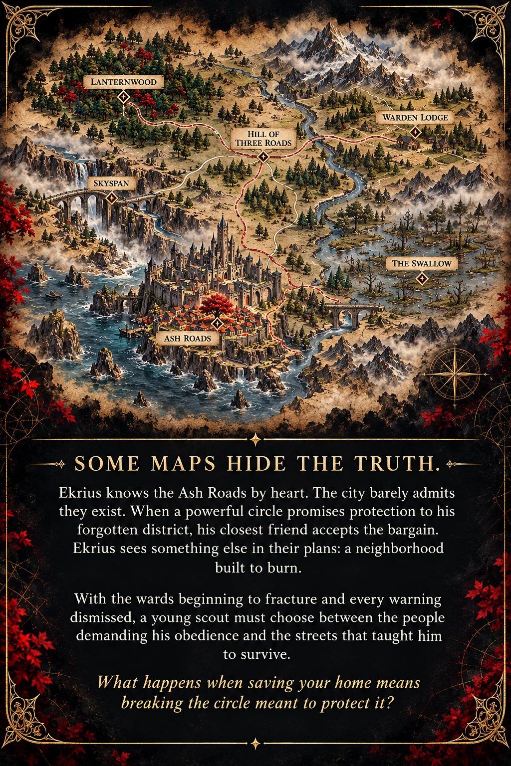
Regional map showing Ash Roads, Lanternwood, Skyspan, the Swallow, the Hill of Three Roads, and Warden Lodge.
Explore by place name using the landmark buttons. Distances are not drawn to scale.

The roads of Ekrius

The map fits your window. Zoom in for finer detail; press Escape or Close to return.

Enlarged regional map: Lanternwood northwest, Skyspan west, Ash Roads southwest, the Hill of Three Roads at the center, Warden Lodge northeast, and the Swallow east

Choose a landmark

Where the six begin

The Ash Roads

Crowded rooms, market errands, temple lamps, and a crimson tree. The city’s official maps overlook much of what makes these streets a home. This is where the friends first learn to see differently.

Life and voices along this road

Life along the road

Market errands, temple lamps, shared meals, and a crimson tree make this district a home long before anyone calls it a cause.

A local perspective

Jarik knows the value of an extra bowl. A neighborhood can feed someone whom its official records barely acknowledge.

Who gets protected when a city decides which streets count?
More than places on a map.

Explore the communities that make these roads a home.

Book One · Chapter atlas

A map beside the story.

Seven illustrated guides help you picture the places in each chapter. Start with the neighborhood, then open later maps as you reach them. Later chapter titles and landmarks may reveal where the adventure goes.

About these maps

Based on the October 2026 manuscript. These are artistic interpretations, not surveyed plans: distances, building placement, and connections are illustrative. Separate panels do not imply adjacent locations.

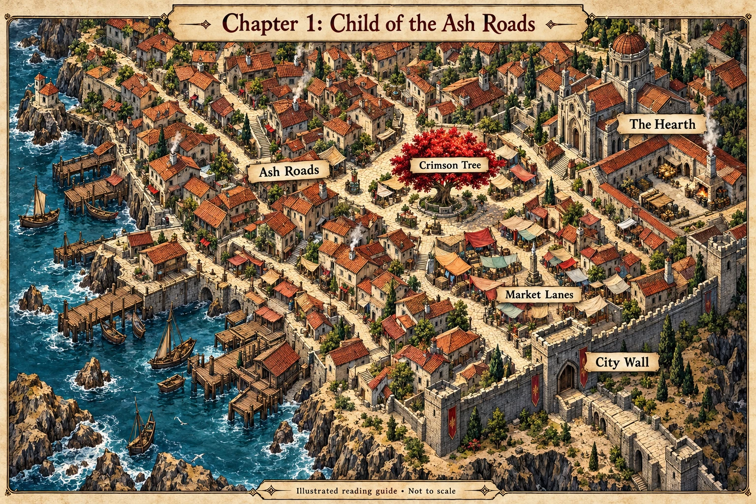
Chapter 1 Child of the Ash RoadsNeighborhood guide

Find the everyday places that shape the six friends: the crimson tree, the Hearth, market lanes, and the city wall. Use this map alongside their childhood errands and first discoveries.

Chapter 1: Child of the Ash Roads. Illustrated map showing Ash Roads, Crimson Tree, the Hearth, Market Lanes, City Wall.
Chapter 1 reading companion · Not to scale. Open the image for a larger view.
View full-size map (opens in a new tab) ↗
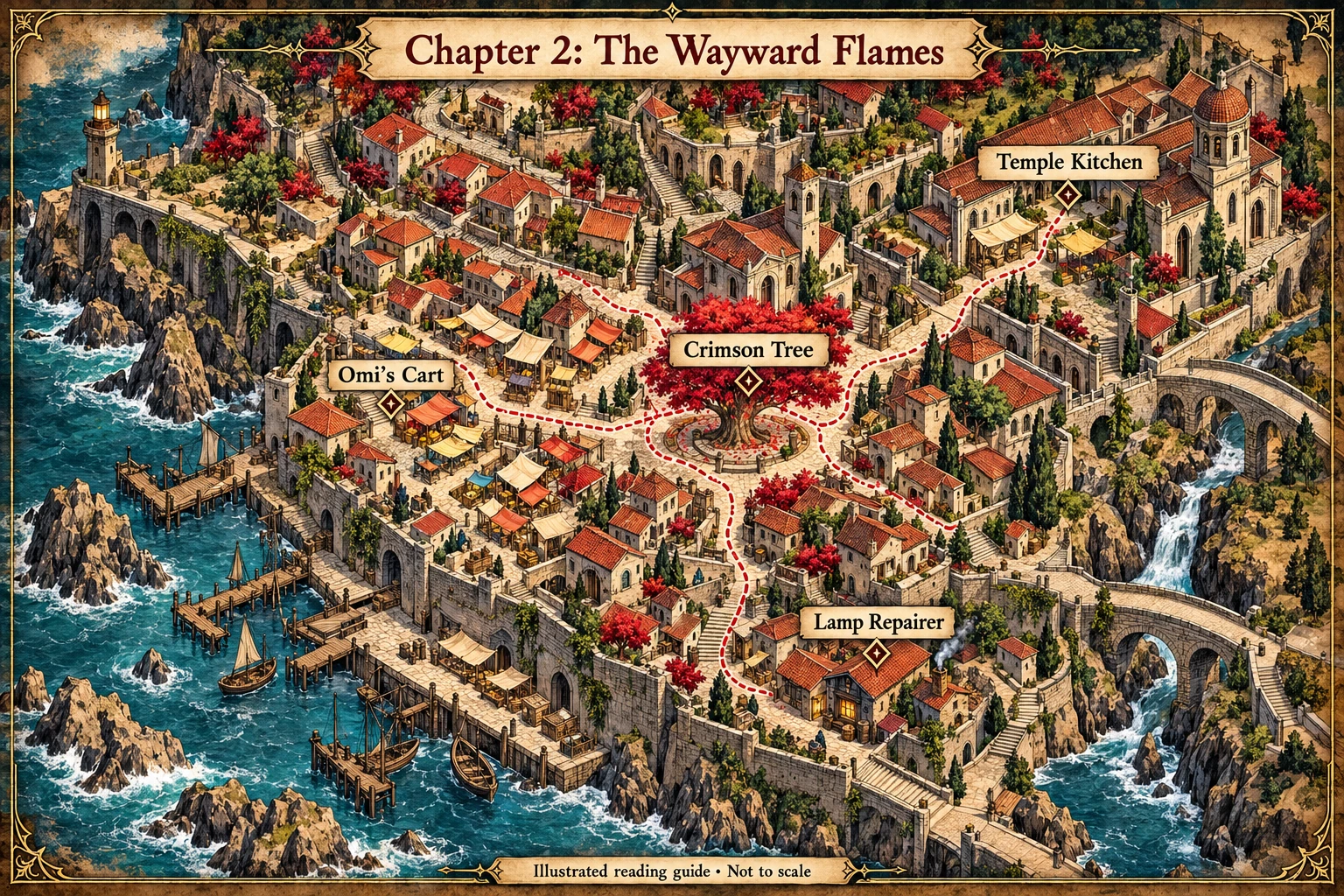
Chapter 2 The Wayward FlamesReveal chapter map · location spoilers

Follow the company’s connections through shared meals, market work, and small jobs. The dotted walks illustrate relationships between gathering and working places, rather than a fixed itinerary.

Chapter 2: The Wayward Flames. Illustrated map showing Crimson Tree, Temple Kitchen, Omi’s Cart, Lamp Repairer.
Chapter 2 reading companion · Not to scale. Open the image for a larger view.
View full-size map (opens in a new tab) ↗
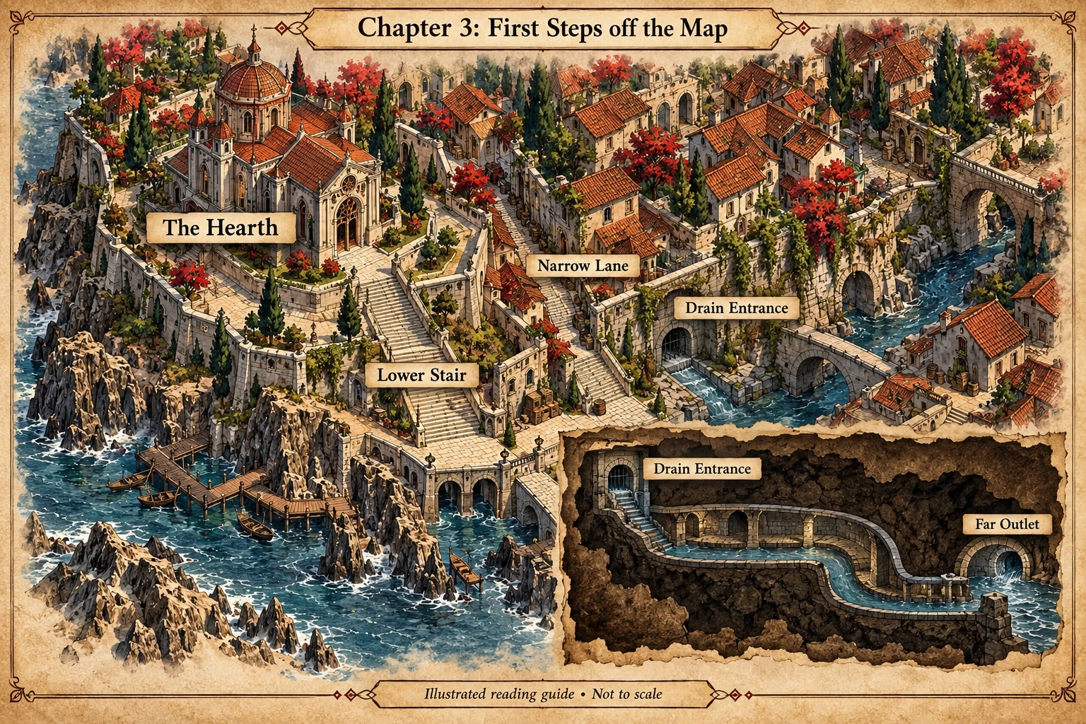
Chapter 3 First Steps off the MapReveal chapter map · location spoilers

Orient yourself around the temple district, the lower stair, and the old drain. The cutaway separates the underground passage from the streets above; it shows the terrain without promising a safe way through.

Chapter 3: First Steps off the Map. Illustrated map showing The Hearth, Lower Stair, Narrow Lane, Drain Entrance, Far Outlet.
Chapter 3 reading companion · Not to scale. Open the image for a larger view.
View full-size map (opens in a new tab) ↗
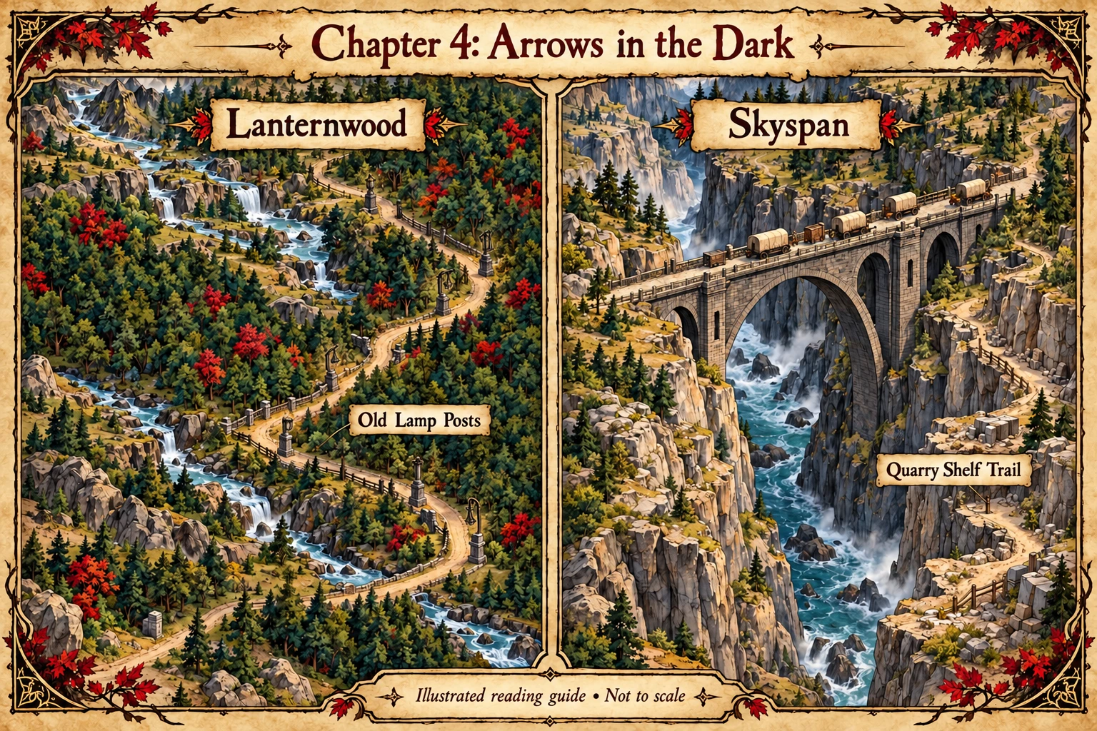
Chapter 4 Arrows in the DarkReveal chapter map · location spoilers

Compare two separate stages of the wider journey: Lanternwood’s old lamp posts and Skyspan’s gorge crossing. The panels are separate settings, not neighboring stops or a continuous route.

Chapter 4: Arrows in the Dark. Illustrated map showing Lanternwood, Old Lamp Posts, Skyspan, Quarry Shelf Trail.
Chapter 4 reading companion · Not to scale. Open the image for a larger view.
View full-size map (opens in a new tab) ↗
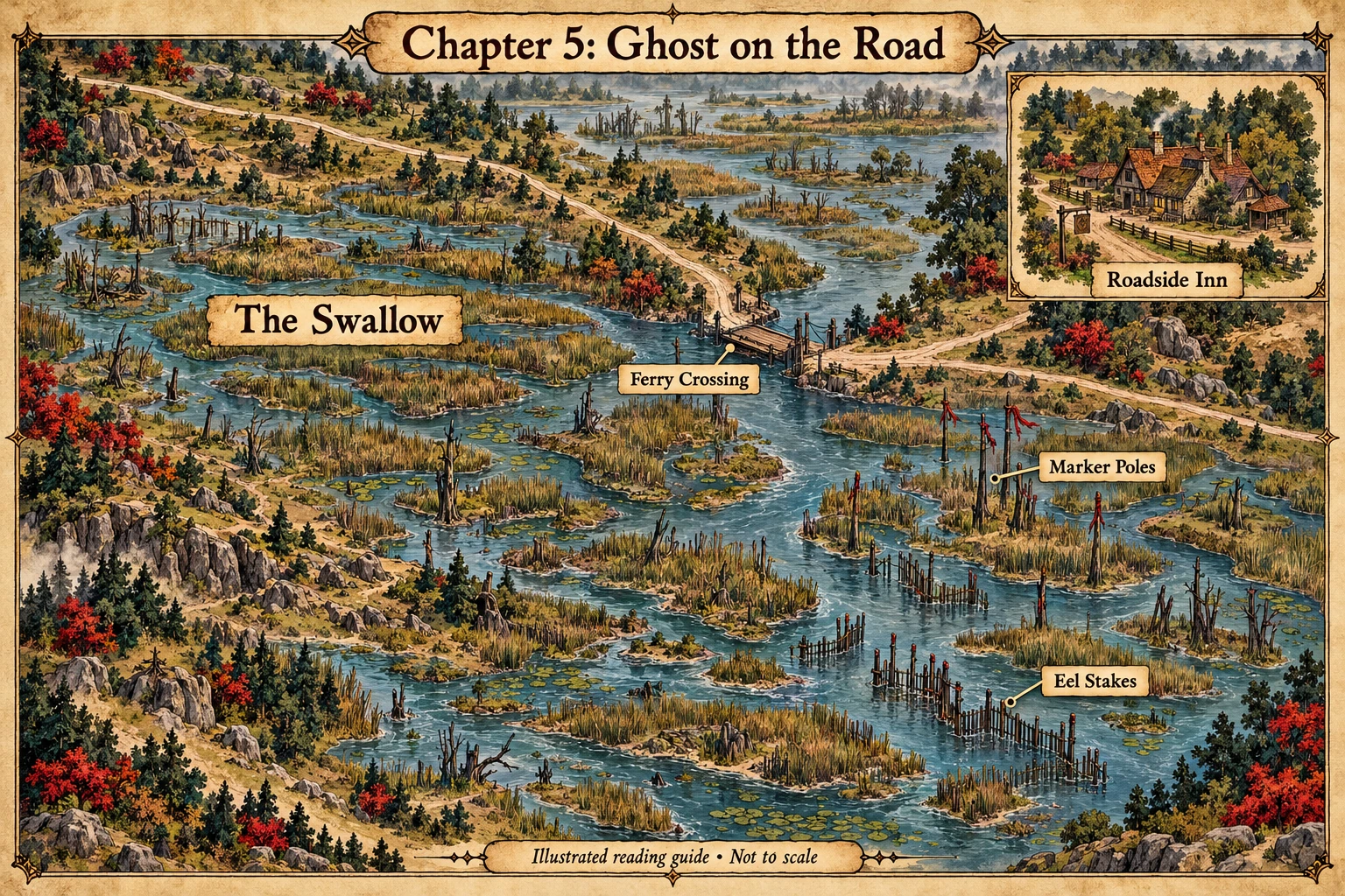
Chapter 5 Ghost on the RoadReveal chapter map · location spoilers

Read the Swallow through its channels, ferry, stakes, and marker poles. A separate inn inset represents the company’s time between journeys; it does not place that inn beside the ferry.

Chapter 5: Ghost on the Road. Illustrated map showing The Swallow, Ferry Crossing, Marker Poles, Eel Stakes, Roadside Inn.
Chapter 5 reading companion · Not to scale. Open the image for a larger view.
View full-size map (opens in a new tab) ↗
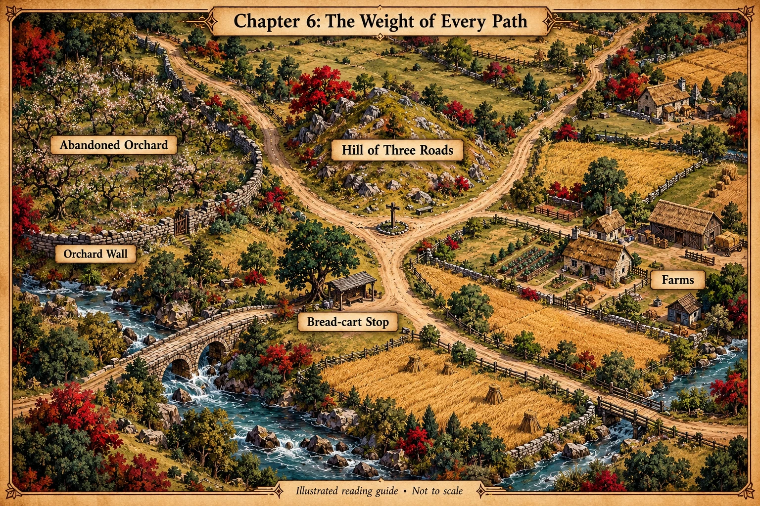
Chapter 6 The Weight of Every PathReveal chapter map · location spoilers

Keep track of the three-way junction, nearby farms, the bread-cart gathering place, and the orchard. This map introduces the landscape the friends must interpret without identifying threats or revealing the mission’s outcome.

Chapter 6: The Weight of Every Path. Illustrated map showing Hill of Three Roads, Farms, Bread-cart Stop, Abandoned Orchard, Orchard Wall.
Chapter 6 reading companion · Not to scale. Open the image for a larger view.
View full-size map (opens in a new tab) ↗
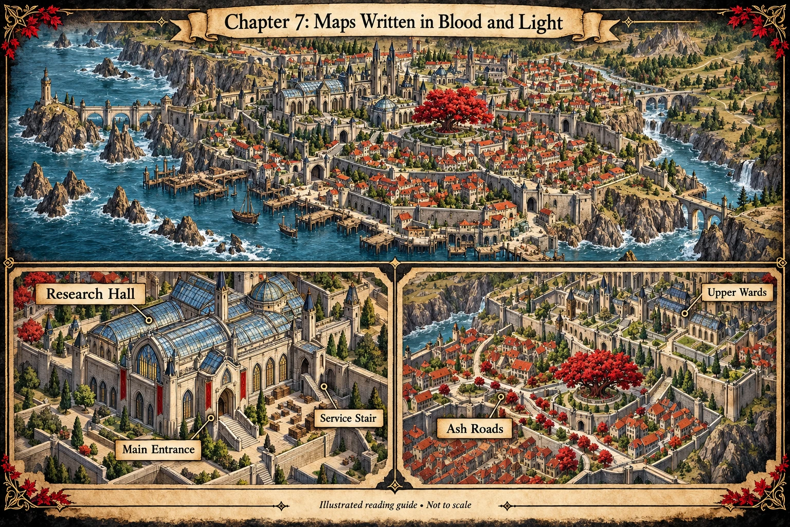
Chapter 7 Maps Written in Blood and LightReveal chapter map · location spoilers

Use the research-hall inset to follow entrances and service access, then the city inset to place the Ash Roads in the wider ward system. The ward connections are illustrative, not a technical circuit or a revealed solution.

Chapter 7: Maps Written in Blood and Light. Illustrated map showing Research Hall, Main Entrance, Service Stair, Ash Roads, Upper Wards.
Chapter 7 reading companion · Not to scale. Open the image for a larger view.
View full-size map (opens in a new tab) ↗

A world by Joel Lomnick. Book One begins the planned six-book journey.

An independent fantasy passion project inspired by tabletop roleplaying. Character and cover artwork created with AI assistance under the author’s direction.